By P.K.Balachandran/Daily Mirror
Colombo, September 24: On Monday September 23, the United Nations had convened a Climate Action Summit (CAS) with concrete and realistic plans to accelerate action to implement the 2016 Paris Agreement on climate change. The Paris Agreement covers issues such as mitigation of greenhouse gas emissions, climate adaptation and finances to back mitigation programs.
Colombo: The International Monetary Fund (IMF) had said in its latest economic assessment, that among UN member nations, Bangladesh is especially vulnerable to climate change, with one-third of the population at risk of displacement because of Rising Sea Levels (RSL).
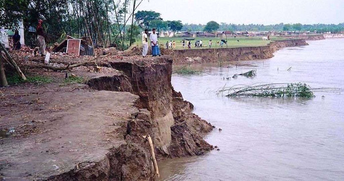
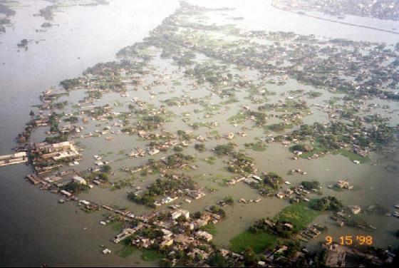
The report says that 60% of Bangladesh’s land surface is at five meters or less above the sea level, and therefore subjected to natural disasters. The worst episode of flooding occurred in 1998 affecting over two-thirds of Bangladesh. The damages and losses were estimated to be 5% of the country’s GDP.
A third of Bangladesh’s population of 165 million could be at risk of displacement because of Rising Sea Levels and coastal erosion, which could lead to a loss of 17% of land surface and 30% by 2050, the IMF warned.
The saddest part is that Bangladesh is suffering immensely though it accounts for less than 0.35% of global greenhouse gas emissions.
Salinity
Economist Iftikhar Iqbal of the University of Brunei, in his well-argued paper published in India’s Economic and Political Weekly says that as against the Food and Agricultural Organization’s prescribed salinity level of ½ gram per kilogram (kg) of water, the salinity level in some coastal areas of Bangladesh ranges from 4 grams per kg in the monsoon season and up to 13 grams per kg in the dry season.
Agricultural land affected by soil salinity has been found to be 0.83 million hectares (ha), 1.02 million ha and 1.06 million ha in 1973, 2000 and 2009, respectively. Altogether, about 20 million of the 37 million Bangladeshis living in the coastal areas are susceptible to the problem of excessive salinity.
Role of Barrages
Iqbal blames it on the construction of river barrages.
“The sluggish water current due to barrages and other water management structures put on the major rivers flowing from India to Bangladesh was another factor that caused salinity. The Farakka barrage on the Ganges across the border, in operation since 1975, significantly slowed the river current, allowing oceanic water to penetrate inside the land,” he says.
Shrimp Farming
Since the 1980s, shrimp cultivation and the poor drainage associated with it in the coastal regions, has been another major factor causing salinization in coastal Bangladesh.
Of all the exportable fish in Bangladesh, valued at US$ 437.40 million annually, about 57% comes from shrimp cultivation on 0.276 million ha of land, inviting the inflow of saline water.
Deforestation
Bangladesh is cyclone-prone because of its geographical location and exposure to a strong monsoon trail. This is due to de-forestation, Iqbal says. According to an Asian Development Bank (ADB) report of 2016, Bangladesh ranks third in Asia with the lowest proportion of forests (11%).
The extent of damages from cyclones to human life and property depends mostly on the extent of protection provided by the “forest belt” of the Sundarbans on the Bay of Bengal. But the forest belt in the Sundarbans has been systematically destroyed by humans since 1876.
“This led to the death of almost half a million people in the cyclone of 1970, which remains the deadliest of all cyclones in recorded history,” Iqbal recalls.
However, since the 1991 cyclone, when about 150,000 people perished, there has been a “remarkable decrease” in cyclone-related death and injuries due to the installation of early warning systems and also the construction of cyclone shelters for humans as well as animals.
Flooding
About 3.48 million people are affected every year by flooding in the country. Bangladesh has the highest percentage of GDP affected by flooding in the Asia Pacific region.
Deforestation in the higher regions outside Bangladesh, such as in North-Eastern India and Nepal, has led to flash floods in Bangladesh. The construction of barrages, including Farakka in India, that withdraws water during the lean season and opens the sluice gates during the monsoon season, contributes to both drought and flooding in Bangladesh, Iqbal points out.
Illegal encroachment of riverbanks also causes flooding. “Bangladesh is essentially a massive natural basin blocked by man-made structures all over,” he points out.
In some parts of the Sundarbans forests, especially in the extreme southern edge, erosion is taking place due to lack of sediment supply, which again is caused by the Farakka and other barrages and dams upstream. Another factor causing land erosion is the training of rivers that take place during the construction of major bridges.
Nature Not Only Cause
According to Iqbal, climate change and the natural disasters triggered by it are not always responsible for migration from the rural areas to the city. Many of the causes are man-made. Deforestation and building of dams, barrages, and railways and roads and housing colonies on river embankments have upset the environment and caused displacement.

Why Migrate To Dhaka?
In Bangladesh, the capital city of Dhaka attracts migrants like no other city in the country. This is not only due to natural disasters striking the rural areas. It is because Dhaka is the only beehive of economic, social and educational activity in the country. This attracts people from the rural areas like a magnet.
Dhaka’s population is growing at more than 4%, way above the national average. More than 18 million or roughly one-tenth of the country’s population lives in this city. This makes Dhaka one of the world’s most densely populated cities, with more than 45,000 people inhabiting per square km.
“Almost 40% of Bangladesh’s GDP originates in Dhaka and its surrounding areas. Over the past two decades, the industrial and service sectors in have seen remarkable growth in Bangladesh, while the agricultural sector has shrunk. The percentage of employment in agriculture has steadily declined from 69.51% in 1991 to 40.15% in 2018,” Iqbal notes.
The garment sector in Bangladesh, which is the second largest after China, is located primarily in Dhaka and its surroundings. At least 80% of factories are located in the greater Dhaka region. Most of Dhaka’s GDP is generated in the more than the 4,000 garment units employing about 5 million personnel. This sector is still showing signs of growth, with annual earnings of more than US$ 32 billion in 2018, the economist points out.
As a result of all this, by 2025, with a population of 22 million, Dhaka is expected to overtake Shanghai, New York and Karachi to secure the fourth place among the megacities, he predicts.
Social Factors
There are certain social factors that have contributed to migration to Dhaka. In 2011, about 38.7% of internal migration took place due to marriage. For the same year, the share of migration due to family quarrel and women tortured or deserted by spouse was 1.2% and 0.2%, respectively. Natural calamity accounted for 2.1%.
Therefore social and economic factors tend to be more important for migration than climate change, Iqbal points out.
No One-Way Street
The other aspect the economist points out is that the road to Dhaka is not a one-way street. Out migration is more than half of in-migration. Therefore, not all blame can be put on climate change and the lopsided economic development of Bangladesh. The significant out-migration shows that the rural areas are not that disaster-prone to be unlivable.


